Architectural project management involves much more than developing drawings and coordinating design decisions. Architects frequently need to review existing conditions, communicate with contractors, clarify construction details, monitor implementation, and verify that completed work follows the approved design.
These responsibilities become more complicated when project teams work from different locations.
An architect may be based in one city while the construction site is hundreds of miles away. Contractors may require clarification about a specific wall, opening, structural element, or finishing detail. Meanwhile, project owners expect regular updates without delays or unnecessary travel expenses.
Traditional communication methods can make this process difficult. Photographs may lack context, written descriptions can be interpreted differently, and important decisions may become scattered across emails, messaging applications, and project documents.
3D site tours provide another way to coordinate architectural projects remotely.
By allowing project participants to navigate through a visual representation of a real building, virtual tours can improve spatial understanding, clarify instructions, and support more effective communication between architects, contractors, and property owners.
When combined with task management tools, they can also help teams connect individual assignments with the exact locations where work must be performed.
Why Remote Architectural Project Management Is Challenging
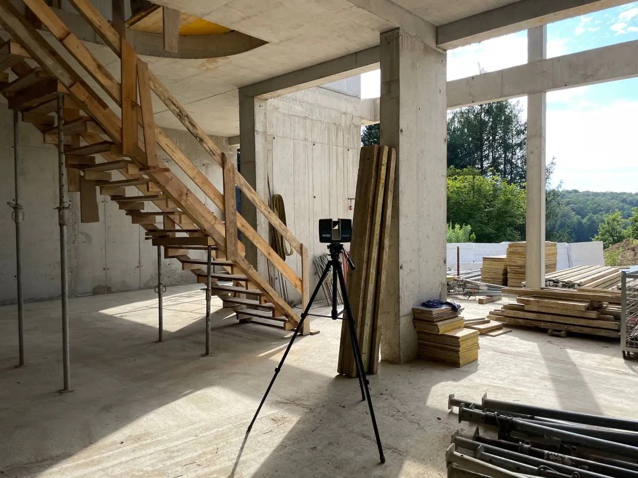
Architectural projects depend on accurate communication about physical spaces.
A design instruction may be technically correct but still difficult for a contractor to interpret without seeing the surrounding environment.
For example, an architect might request a correction to a wall finish near a doorway. If several similar doorways exist on the same floor, the contractor may need additional photographs, drawings, or explanations to identify the correct location.
Similar problems occur when coordinating lighting installations, interior partitions, ceiling details, mechanical equipment, or changes to existing structures.
Remote project management introduces several recurring challenges.
Limited Visibility Into Existing Conditions
Architects need to understand the actual condition of a building before making decisions.
Floor plans and photographs provide valuable information, but they may not fully communicate the relationships between rooms, openings, equipment, and architectural elements.
When existing documentation is incomplete or outdated, remote coordination becomes more difficult.
Misunderstandings Between Project Participants
Architects, contractors, engineers, and owners may interpret the same instruction differently.
A photograph can show the problem without identifying its exact location.
A drawing can indicate a room or element without showing the current condition of the surrounding space.
These gaps can lead to clarification requests, incorrect work, and unnecessary site visits.
Fragmented Project Communication
Project information is often distributed across multiple systems.
Drawings may be stored in one platform, photographs in another, and contractor discussions in email or messaging applications.
Even when teams use architectural project management software, the physical location associated with a particular task may not be immediately clear.
Difficulties Verifying Completed Work
After a contractor completes an assignment, the architect needs to confirm that the result meets the design requirements.
For some activities, photographs and supporting documentation are sufficient.
Other work requires direct measurements, physical inspection, or professional verification on-site.
A remote management process must distinguish between these situations.
What Is a 3D Site Tour?
A 3D site tour is a navigable visual representation of a physical building, interior, or facility.
Depending on the capture method and platform, it may consist of connected panoramic images, spatially organized photographs, or a more detailed digital representation of the property.
Users can move through the environment remotely and examine rooms, corridors, architectural features, and other visible elements.
Unlike a collection of separate photographs, a virtual tour helps preserve the spatial relationships between different parts of a property.
For architects, this can provide useful context when reviewing existing conditions or discussing project details.
A 3D site tour should not automatically be considered equivalent to a BIM model or a continuously updated digital twin.
It primarily represents the property at the time of capture.
If construction work changes the environment, the tour may need to be updated or supplemented with current photographs and documentation.
How 3D Site Tours Support Remote Architectural Projects
1. Reviewing Existing Building Conditions
Before planning renovation or reconstruction work, architects need reliable information about the existing building.
A 3D tour can help teams examine room layouts, visible architectural elements, access routes, and the relationships between different spaces.
For example, an architect preparing an interior renovation can revisit a captured room to review window positions, ceiling features, or existing finishes.
This may reduce the need for additional visits to clarify basic visual details.
However, accurate dimensions, structural assessments, and technical design decisions may still require measured surveys, laser scanning data, or other professional documentation.
2. Clarifying Design Requirements
Construction drawings remain essential, but contractors sometimes need additional visual explanations.
A virtual tour allows architects to show the area being discussed rather than relying entirely on written descriptions.
For example, an architect can identify the location of a proposed partition, explain a finishing detail, or clarify which existing element should remain unchanged.
The surrounding visual context can make the instruction easier to understand.
This is especially useful for renovation projects where existing conditions differ from original drawings.
3. Coordinating Contractors Across Multiple Locations
Architectural teams may oversee several projects simultaneously.
Traveling to every property for routine clarification can consume considerable time.
With a virtual tour, an architect can review a location remotely, communicate requirements, and determine whether a site visit is necessary.
This approach can be particularly valuable for firms managing commercial interiors, retail fit-outs, residential renovations, and distributed property portfolios.
4. Documenting Construction Issues
During construction or renovation, teams frequently identify problems that require correction.
These may include damaged finishes, incorrectly positioned fixtures, incomplete installations, or discrepancies between the design and visible site conditions.
A virtual tour provides a visual reference for documenting the location of an issue.
When observations are connected with specific locations, project participants can more easily understand which area requires attention.
5. Reviewing Contractor Progress
Architects often need to review completed work before approving the next stage of a project.
A 3D tour can help establish the original visual context, while updated photographs and reports document subsequent progress.
For example, an architect may review photographic evidence of a corrected wall finish or completed fixture installation.
If the submitted materials are sufficient, the task may be reviewed remotely.
If measurements, concealed conditions, safety requirements, or technical compliance must be verified, an on-site inspection remains necessary.
Combining 3D Site Tours with Architectural Project Management Software
A virtual walkthrough provides spatial context, but viewing a building does not automatically create an effective project management process.
Architects also need to assign responsibilities, establish deadlines, communicate corrections, and monitor completion.
Traditional architectural project management software typically focuses on schedules, project documentation, communication, budgets, and coordination.
These functions remain important.
However, when tasks concern physical locations, teams may benefit from a system that connects assignments directly with the visual environment.
For example, location-based task management with ScanTrack allows project participants to create tasks at specific points inside a 3D tour.
An architect can navigate through the property, identify an area requiring attention, and create an assignment associated with that location.
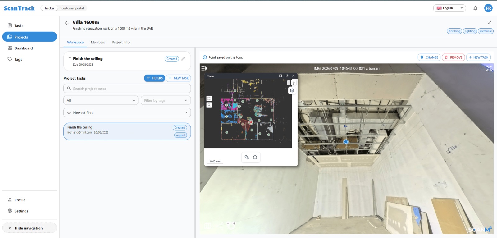
The responsible contractor can review the visual context, follow the instructions, and submit photographs or other evidence after completing the work.
The architect can then review the submitted materials and determine whether the task is ready for closure.
This approach does not replace design software, BIM authoring tools, or comprehensive project management systems.
Instead, it adds a visual coordination layer for work that must be performed at specific physical locations.
Example: Managing an Interior Renovation Remotely
Consider an architecture firm overseeing the renovation of a commercial office.
The project includes new partitions, lighting fixtures, ceiling finishes, and interior modifications.
The architect is responsible for coordinating design requirements and reviewing selected stages of the work.
Step 1. Capture the Existing Space
Before renovation begins, the team creates a 3D tour of the property.
The tour provides a shared visual reference for the architect, contractor, and project owner.
It allows participants to examine the existing rooms, corridors, and architectural features remotely.
Step 2. Identify Areas Requiring Work
During the planning and coordination process, the architect identifies several locations requiring modifications.
These may include a wall opening, a ceiling area, or a particular section of interior finishing.
Each issue can be documented with its location and supporting instructions.
Step 3. Assign Responsibilities
The architect or project manager assigns tasks to the relevant contractors.
Each assignment includes a description of the required work, a deadline, and supporting materials.
When the task is connected with the virtual environment, the contractor can examine the location before arriving.
Step 4. Collect Progress Updates
Contractors complete the assigned work and submit photographs or other documentation.
These updates help the architect understand what has changed since the original tour was captured.
They also provide a record of completed activities.
Step 5. Review the Results
The architect reviews the submitted evidence.
Visible finishing details may be checked remotely when the photographs provide sufficient information.
Other work, such as concealed installations or elements requiring precise measurements, must be verified through appropriate on-site procedures.
Step 6. Close or Reassign Tasks
If the work meets the requirements, the task can be closed.
If corrections are necessary, the architect can provide additional instructions while preserving the original location context.
This creates a documented process from identifying an issue to verifying its resolution.
Benefits of Using 3D Site Tours for Architects
Reduced Need for Clarification Visits
Architects may be able to resolve certain questions remotely when the virtual tour provides enough visual information.
This can reduce travel for routine clarifications, although the actual savings depend on project complexity and inspection requirements.
More Precise Communication
A visual reference helps contractors understand the location and surroundings of a task.
This can be particularly valuable in large buildings or projects with repetitive room layouts.
Better Coordination with Project Owners
Owners may not be familiar with architectural drawings or technical terminology.
A virtual tour provides a more accessible way to understand the physical areas being discussed.
This can support clearer communication about proposed changes and outstanding issues.
Improved Documentation
When tasks, photographs, comments, and status updates remain connected with specific locations, project teams can maintain a clearer record of decisions and completed work.
Easier Management of Multiple Projects
Architects overseeing several properties can use virtual tours to review locations and coordinate routine tasks without visiting every site for every update.
This does not eliminate the need for physical supervision, but it can help teams prioritize visits.
3D Site Tours vs. BIM Models
3D site tours and BIM models serve different purposes.
A virtual tour is primarily a visual representation of an existing physical environment.
A BIM model is a structured digital model containing geometry and, depending on the project, information about building elements and systems.
Both can support architectural coordination, but they are not interchangeable.
For many architectural projects, the two approaches can complement each other.
BIM models help teams coordinate design information, while 3D site tours provide visual access to captured physical conditions.
The appropriate combination depends on the project and its documentation requirements.
When Remote Architectural Supervision Is Not Enough
Although 3D site tours can improve communication, they cannot replace every site visit.
Some activities require direct professional inspection.
These include situations involving:
· Structural safety and concealed construction elements.
· Verification of critical dimensions and tolerances.
· Testing of building systems and equipment.
· Regulatory inspections and code compliance.
· Materials or installation quality that cannot be assessed from photographs.
· Conditions that have changed significantly since the tour was captured.
Architects should determine which decisions can be supported by remote visual evidence and which require direct examination.
A virtual tour is most useful as a coordination and documentation tool rather than a substitute for professional responsibility.
How to Introduce 3D Tours into an Architectural Workflow
Adopting virtual tours does not necessarily require replacing existing project management software.
A practical implementation can begin with a limited pilot project.
Choose a Suitable Project
Select a building where remote communication frequently creates delays or requires clarification.
Renovation projects, commercial interiors, and properties with multiple contractors are useful candidates.
Create a Reliable Visual Reference
Capture the areas relevant to the project.
The quality and completeness of the visual material directly affect how useful the tour will be.
Define Task Management Procedures
Establish how issues will be documented, who assigns tasks, and what evidence contractors must submit.
Clear responsibilities are important regardless of the software used.
Test Remote Review
Begin with activities that can be verified visually.
Examples may include visible finishing corrections, fixture replacement, or cleaning work.
Do not use remote photographs as the sole verification method for safety-critical or concealed work.
Evaluate the Results
After the pilot project, review whether the workflow reduced clarification requests, improved task communication, or made project records easier to manage.
Use those findings to decide whether the approach should be expanded to other projects.
Choosing the Right Architectural Project Management Tools
Architectural project management software should support the actual needs of the firm.
Some teams primarily require document management, scheduling, and communication.
Others need BIM coordination, issue tracking, construction administration, or visual access to existing buildings.
When evaluating software, architects should consider several questions.
Does the platform support the existing design workflow? Project management tools should complement established drawing, BIM, and documentation processes.
Can the team communicate the exact location of an issue? For renovation and site coordination, location context may be as important as the task description.
Can contractors submit evidence of completed work? Photographs, documents, and status updates can support remote review.
Does the system preserve a clear record of decisions? Project teams should be able to understand what was requested, who was responsible, and how the issue was resolved.
Can the workflow scale across multiple projects? Firms managing distributed sites may benefit from standardized procedures for task assignment and remote coordination.
The most effective solution is not necessarily the platform with the longest feature list.
It is the one that fits the firm's existing responsibilities and reduces avoidable communication problems.
Final Thoughts
Remote architectural project management depends on accurate information, clear instructions, and reliable communication between everyone involved in a project.
3D site tours can improve this process by giving architects, contractors, and property owners a shared visual reference.
Instead of interpreting isolated photographs or lengthy written descriptions, project participants can examine the relevant physical environment remotely.
When virtual tours are combined with location-based task management, teams can connect instructions, responsibilities, deadlines, and completion evidence with specific areas of a building.
This can make routine coordination more efficient and help architects focus site visits on work that genuinely requires direct professional attention.
For architecture firms managing renovations, commercial interiors, and multiple properties, 3D site tours offer a practical addition to existing project management and construction administration workflows.
About the Author
Violetta Bonenkamp, also known as MeanCEO, is an experienced startup founder with an impressive educational background including an MBA and four other higher education degrees. She has over 20 years of work experience across multiple countries, including 5 years as a solopreneur and serial entrepreneur.